For geology, one of the most fundamental questions to ask is “Where is something located?” Why does this matter? Because the landscape (physical geography) is largely controlled by the geology; we can understand why and how the landscape came to be by understanding the geology. Also, different places have somewhat different geologic histories; by knowing what happened and where, we can piece together a more coherent story of earth history. Finally, many earth resources occur in rocks (metal ores, petroleum), but they occur only in specific places; we need to understand the geology of different places to assess their resource potential.
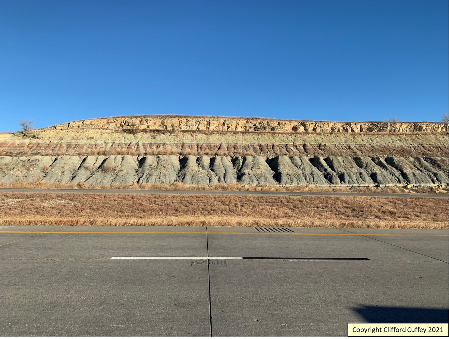
Here is a roadcut. Where is it? How do we describe its location? There are a lot of different ways to accurately describe this roadcut’s location. Each method has a different degree of precision. The more precise the location is known, the more useful the information is. Here is a series of locations that are accurate:
1) The roadcut is in Kansas.
2) The roadcut is in Geary County, Kansas.
3) Approximately 16-1/2 miles (26-1/2 kilometers) east of Junction City, Kansas
4) Approximately 8-1/2 miles (13 kilometers) south-southeast of Manhattan, Kansas
5) Approximately 18 miles (29 kilometers) east of Junction City, Kansas, as measured along Interstate highway 70.
6) The roadcut is along Interstate highway 70, between exits 313 and 316, near Manhattan, Kansas.
These are all accurate statements. But they are not very precise (although with varying degrees of precision). The “gold standard” for recording and describing the location is to ask yourself, “If someone gave you directions, would you be able to drive right up to the roadcut without any difficulty and without any question you were at the right location?” There are a lot of roadcuts in Kansas, and even in Geary County! Which one is it precisely? Here are three ways to much more precisely locate the roadcut, such that you can put a dot on a detailed map and drive right up to it:
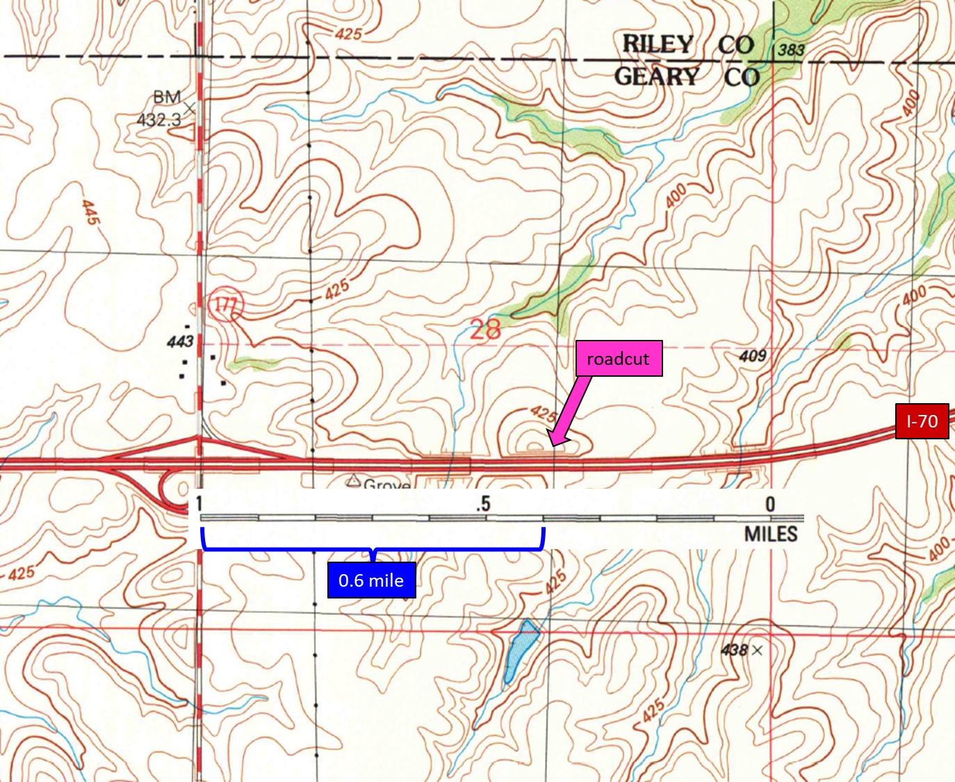
1) Roadcut on north side of westbound lanes of Interstate highway 70, 0.6 mile (1.0 kilometer) east of the exit to Kansas state highway 177 (as measured from the bridge over 177); in northeasternmost Geary County, and approximately 8-1/2 miles (13 kilometers) south-southeast of Manhattan, Kansas.
2) Latitude / longitude coordinates: 39.062956 north / 96.527230 west; in northeasternmost Geary County, and approximately 8-1/2 miles (13 kilometers) south-southeast of Manhattan, Kansas.
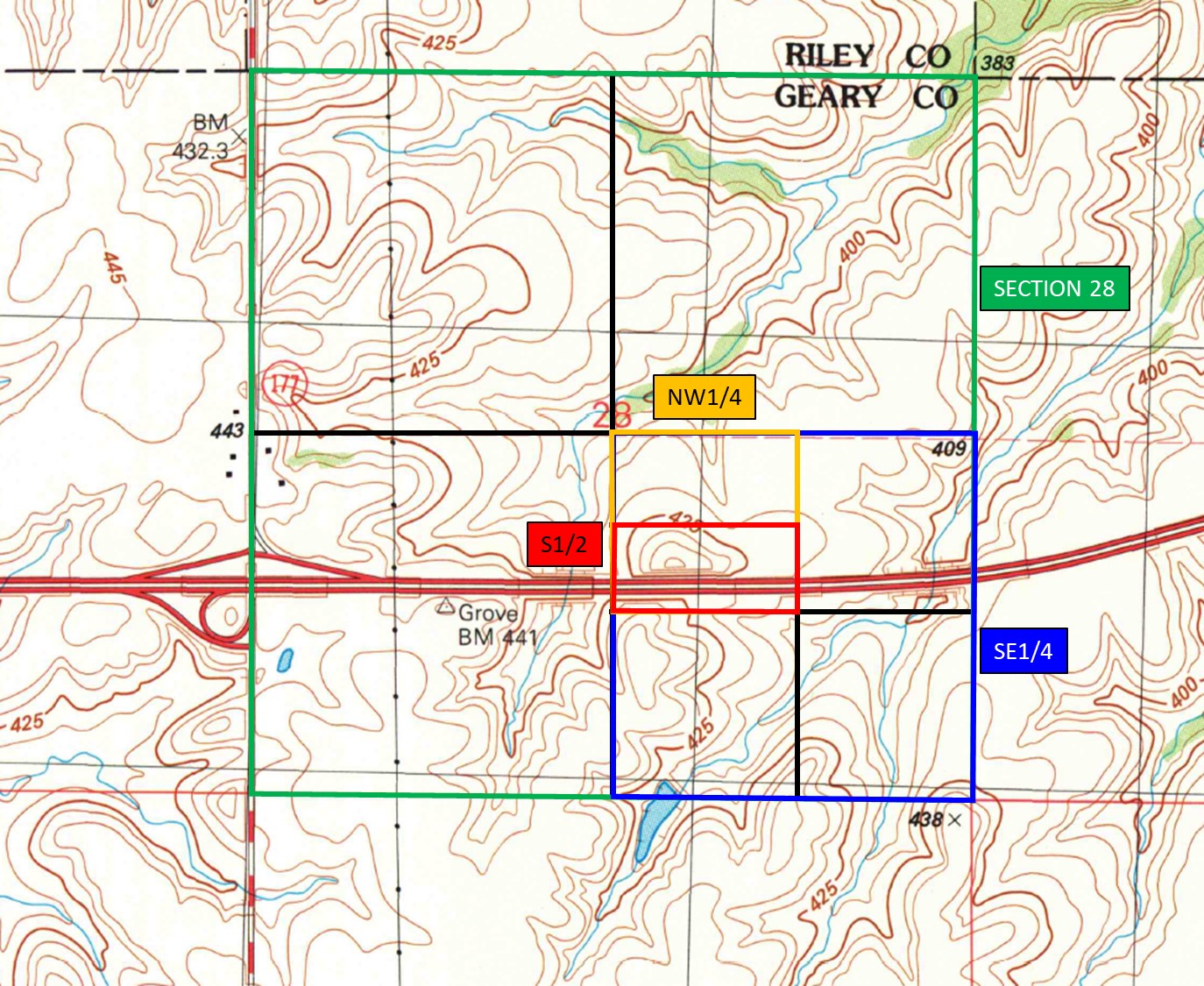
3) Public Land Survey grid: S1/2 NW1/4 SE1/4 section 28, T11S, R8E. Swede Creek, Kansas, 7.5-minute topographic quadrangle map; in northeasternmost Geary County, and approximately 8-1/2 miles (13 kilometers) south-southeast of Manhattan, Kansas.
These location descriptions describe in two-dimensions where the outcrop is. But even Kansas is not perfectly flat. We also need to know the ground elevation at the roadcut. As we will see later, as you go up and down the hills along the highway, you go up and down through different rock layers. The rock layers are very much like the layers of a cake, or a pan of lasagna, or a pan of flat enchiladas. In the simplest form, you can note whether the roadcut is uphill, downhill, or level with other roadcuts. Again, to be precise, we can use the topographic map and get an elevation! Our roadcut is approximately 1400 to 1450 feet (425 to 440 meters) above sea-level. Now we have a very precise and accurate location of the roadcut in three-dimensions! Welcome to the world of the science of geology. Now we can begin to ask lots of other questions about the roadcut.

Here is a picture of a small portion of the Swede Creek, KS, 7.5 minute quadrangle topographic map (published by the United States Geological Survey). The roadcut in the photograph is located by the bright pink arrow. We can measure the distance from the exit to state highway 177 either using the scale bar on the topographic map or using the odometer in our vehicle. Also, note the elevation indicated by contour lines and labels (in this case, in meters above sea-level).

Here is another picture of the same small portion of the Swede Creek, KS, 7.5 minute quadrangle topographic map (published by the United States Geological Survey). This illustrates how we use the Public Land Survey grid to describe its location. We first find the roadcut, and determine which section it is in. Then we zoom in on the roadcut using every smaller quarter and half sections, as illustrated. When reporting its location, we work from smallest to largest area like this: south half of the northwest quarter of the southeast quarter of section 28. You need to look at the full scanned image (or paper copy) of the topo map to see the edges to see the township. and ranges. In this case, section 28 is in Township 11 south and Range 8 east. Finally, we write it like this for shorthand: S1/2 NW1/4 SE1/4 section 28, T11S, R8E.
The GPS coordinates can be determined by carrying a hand-held GPS device that will give you the latitude-longitude coordinates of your location. Alternatively, you can find the location of the roadcut on Google Maps, click to add a point, and Google Maps will display the latitude-longitude coordinates for you.

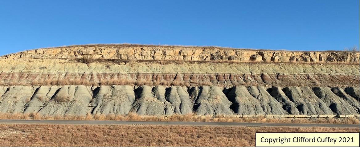
Another one of the most fundamental questions we can ask is “What do we see?” Or alternatively, “What is this?” Here is a zoomed in photo of the same roadcut. What types of rocks do we see? What do those rocks look like?
First, we can see that the rocks in this roadcut are a series of layers. This helps us identify these rocks as sedimentary rocks. And their outward appearance, combined with closer inspection, allows us to determine the types of sedimentary rocks exposed here.
Second, if we look at the colors of the rocks and the slope profile of the rocks, we can see that there are different layers of rocks with different characteristics. At the bottom of the roadcut is a thin layer of tannish-gray limestone. Limestone is a fairly sturdy rock type, and so it forms ledges and bluffs. Above that is a thick layer of gray shale. Shale, being made up of mud, is a fairly soft and weak rock, and so it forms slopes which are commonly gullied. Above that are two more layers of shale, one red and one olive-gray to tannish-gray. At the top is a thick layer of tan limestone with chert (the chert nodules are too small to be seen in this photo).

This annotated photo illustrates my verbal description of the rocks.
Why did I describe these layers from the bottom to the top of the cut? Layers of rock are laid down in succession from bottom to top, like putting different layers of lasagna into a pan; the layer at the bottom goes in first and is oldest; the layer at the top goes in last and is youngest. Therefore, we can read the rock layers from bottom to top like pages in a story book that tells us the history of the earth! More on this another time!
Third, what is the orientation of those rocks? These rock layers are nearly horizontal. Another way to say this is that the rock layers are flat-lying. More on orientation of rock layers another time!